Button CopyPathCircle CloseCircle Left ArrowArrow Down Icon GreyClosecirclecircleBurger
  • Advertising

13145 39 HIGHWAY, Mackenzie, British Columbia, V0J 2C0

MLS® # R3026502
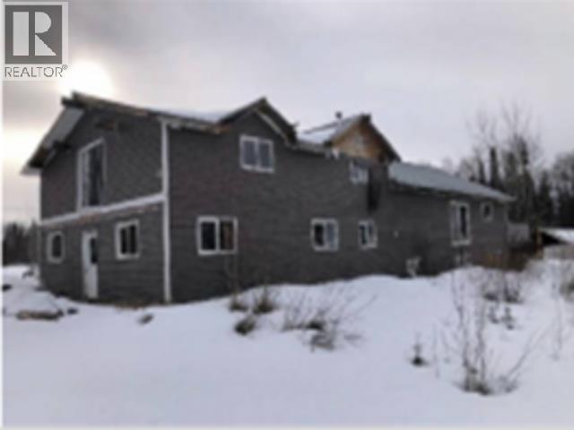
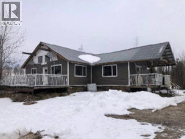
House For Sale In Mackenzie, British Columbia
$259,900 QuickQuoteTM: Not Available

4 Beds

2 Baths

13145 39 Highway, Mackenzie, BC - Outdoor
13145 39 Highway, Mackenzie, BC - Other
13145 39 Highway, Mackenzie, BC - Outdoor With Deck Patio Veranda With Facade
13145 39 Highway, Mackenzie, BC  - Outdoor
13145 39 Highway, Mackenzie, BC  - Other
13145 39 Highway, Mackenzie, BC  - Outdoor With Deck Patio Veranda With Facade
Home Insurance - TD Insurance
Get a home insurance quote online for this $259,900 property in Mackenzie
  • Advertising
Are you a real estate investor?
13145 39 HIGHWAY, Mackenzie, British Columbia, V0J 2C0
$259,900

4 Beds

2 Baths

Property Information:

FORECLOSURE, PRICED $240,000 BELOW TAX ASSESSEMENT! Located 7 km south of Mackenzie, BC, 13145 Highway 39 is a 22.288-acre rural foreclosure property in the Regional District of Fraser-Fort George. The 4-level split home has a metal roof and vinyl siding (some unfinished). It's off-grid, powered by a generator, with water from a private drilled well. Interior work is incomplete-walls, ceilings, flooring, and fixtures need finishing, and one of two bathrooms is only roughed in. The basement has a rec room and crawlspace. No hydro is connected. This property is best suited for a contractor or builder due to its unfinished condition and foreclosure status. (id:27)

Building Features:

  • Style: Detached
  • Building Type: House
  • Basement Development: Unfinished
  • Basement Type: N/A
  • Construction Style - Attachment: Detached
  • Floor Space: 2100 sqft
  • Foundation Type:
  • Roof Material: Metal
  • Roof Style: Conventional
  • Total Finished Area: 2100 sqft

Property Features:

  • OwnershipType: Freehold
  • Property Type: Single Family
  • Bedrooms: 4
  • Bathrooms: 2
  • Built in: 2012
  • Floor Space (approx): 2100 Square Feet
  • Parking Type: Other

Rooms:

  • Primary Bedroom 4.57 m x 3.66 m
  • 2nd Bedroom 3.66 m x 3.05 m
  • 3rd Bedroom 3.66 m x 3.05 m
  • Office Basement Level 4.27 m x 3.66 m
  • Storage Basement Level 3.05 m x 2.44 m
  • Recreation Room Lower Level 5.49 m x 4.27 m
  • 4th Bedroom Lower Level 3.66 m x 3.05 m
  • Storage Lower Level 3.05 m x 2.44 m
  • Kitchen Main Level 3.66 m x 3.66 m
  • Living Main Level 5.49 m x 4.27 m
  • Dining Main Level 3.66 m x 3.05 m
  • Foyer Main Level 3.05 m x 1.83 m
  • Mudroom Main Level 2.44 m x 1.83 m

Convert Measurement to:

Courtesy of: RE/MAX Core Realty, RE/MAX LIFESTYLES REALTY

REALTOR.ca  

QuickQuoteTM Powered by RPS
Thinking of Selling?

Start by finding out what your home might be worth in today's market.

Location of 13145 39 HIGHWAY, Mackenzie, British Columbia, V0J 2C0

Climate Risk Data

About Climate Risk: Properties are at increased risk of damage from extreme weather due to climate change.
ClimateCheck provides detailed climate risk data for properties now and up to 30 years into the future.

Projected Heat Risk: Moderate-Low

22 hot days expected in 2050

Projected Precipitation Risk: Moderate

15 storms expected in 2050

Projected Heat Risk: Moderate-Low

22 hot days expected in 2050

26/100

Moderate-Low

ClimateCheck®

Current data

This property, 13145 39 HIGHWAY , experiences 7 hot days per year at around 27.8 degrees Celsius.

Projected data

Severe heat risk is expected to increase in this area. In 2050, it is projected that there will be 22 hot days at 30.9 degrees Celsius.

Projected Avg. Temperature

Past
27.8℃
2050
30.9℃

# Hot Days Per Year

Past
7
2050
22

About Heat Risk

Heat risk is the number of extreme heat days experienced each year looking at historical conditions (1980-2005) in your area and taking the 2% of the hottest days and projecting that into the future.

Projected Precipitation Risk: Moderate

15 storms expected in 2050

51/100

Moderate

ClimateCheck®

Current data

This property, 13145 39 HIGHWAY , experiences 12 significant 2-day storms per year, with about 236.7mm of precipitation per storm.

Projected data

Severe storms are expected to increase in this area. In 2050, it is projected that there will be 15 significant 2-day storms with 290.4mm of precipitation per year.

Precipitation Per Storm

Past
236.7mm
2050
290.4mm

48-Hour Storms Per Year

Past
12
2050
15

About Storm Risk

Storm risk is the number of high wind, wet or snowy events each year. Climate check looks at historical conditions (1980-2005) in your area, on the days with the top 1% of total precipitation in a year and projected to 2050.

Climate risk data is provided for informational purposes only on Royallepage.ca.
If you have questions or feedback about this data, get help at climatecheck.com.

Environmental Risks provided by ClimateCheck®

Royal LePage does not endorse nor guarantee this information. By providing this information, Royal LePage and its agents are not providing advice or guidance on climate risks. Royal LePage strongly recommends that consumers independently investigate the property’s climate risks to their own personal satisfaction.

Demographic Information of 13145 39 HIGHWAY, Mackenzie, British Columbia, V0J 2C0

Life Stage

Midlife Families

Employment Type

Blue Collar/Primary, Blue Collar/Service Sector

Average Household Income

$134,000.00

Average Number of Children

1.67

Household Population

Household Structure

Age of Population

Education

Education Level

No certificate/diploma/degree

18.53 %

High school certificate or equivalent

37.56 %

Apprenticeship trade certificate/diploma

11.55 %

College/non-university certificate

15.83 %

University certificate (below bachelor)

2.01 %

University Degree

14.51 %

Commuter

Travel To Work

By Car

91.78 %

By Public Transit

0.0 %

By Walking

4.88 %

By Bicycle

0.0 %

By Other Methods

3.34 %

Cultural Diversity

Knowledge of Official Language

Mother Tongue

Building Information

Building Type

Apartments (Low and High Rise)

13.95 %

Houses

86.05 %

Own Vs. Rent